How Glacial Lakes Form and Change Over Time
Glacial lakes are among the most dynamic and visually striking features of landscapes shaped by past and present ice cover. These bodies of water emerge through a combination of glacial erosion, deposition, and subsequent retreat of ice masses. Understanding how these lakes form and transform over time requires a closer look at the processes that begin beneath glaciers and continue long after the ice has vanished. This article explores the stages of glacial lake development, from the initial carving of bedrock to the slow ecological changes that define their lifespan.
The formation of a glacial lake is rarely a single event. Instead, it involves a sequence of geological and hydrological actions that depend on the characteristics of the glacier, the underlying terrain, and the climate conditions at the time. As glaciers advance and retreat, they leave behind a variety of depressions and barriers that can hold water. These features may be carved directly into rock, formed by piles of debris, or created by the melting of buried ice blocks. Each type of glacial lake has a distinct origin and behaves differently over time.
In the United Kingdom, many glacial lakes are found in the Scottish Highlands and the Lake District, where past glaciations sculpted deep valleys and left behind moraines that now contain water. While these lakes are often stable today, their histories are marked by periods of rapid change, including catastrophic drainage events. Examining these processes helps researchers understand not only past environments but also how modern landscapes may respond to future climatic shifts.
The Role of Glacial Erosion in Creating Basins
Before a glacial lake can appear, a basin must be formed that can collect and retain water. One of the primary mechanisms for this is glacial erosion. As a glacier moves downhill, it scours the underlying bedrock through two main actions: abrasion and plucking. Abrasion occurs when rocks embedded in the base of the glacier grind against the bedrock, smoothing and polishing it. Plucking happens when meltwater infiltrates cracks in the bedrock, freezes, and then pulls pieces of rock away as the ice moves. Over time, these processes carve out hollows and troughs that can later become lake basins.
The shape of these basins is often elongated and U-shaped, reflecting the path of the original glacier. In mountainous regions, glaciers may excavate rock basins at the heads of valleys, forming what are known as cirque lakes or tarns. These are typically small, deep, and surrounded by steep cliffs. Further down the valley, the glacier may create a more extensive depression, which later becomes a larger lake. The depth and shape of the basin depend on the duration of glacial occupation, the hardness of the bedrock, and the volume of ice that once filled the valley.
Once the glacier retreats, meltwater begins to accumulate in these newly exposed basins. However, a depression alone does not guarantee a lake. The basin must also have a barrier or dam to prevent water from draining away. This is where glacial deposits come into play.
Moraine Dams and Other Depositional Barriers
Glaciers transport vast amounts of debris, ranging from fine clay to massive boulders. When a glacier melts or retreats, this debris is left behind as piles of unsorted material called moraines. A moraine that forms across a valley can act as a natural dam, impounding water behind it. Such lakes are known as moraine-dammed lakes and are common in formerly glaciated regions. The stability of a moraine dam varies greatly depending on its composition, internal structure, and the presence of ice cores that may later melt.
Moraine dams are not permanent. Over time, they can be breached by water pressure, erosion, or seismic activity, leading to sudden drainage events known as glacial lake outburst floods. These floods can be catastrophic for downstream areas, carrying large volumes of water and sediment in a short time. Researchers study the geometry and sedimentology of moraine dams to assess their stability and to model potential future outbursts. In some cases, the dam may be reinforced by bedrock or vegetation, extending the life of the lake.
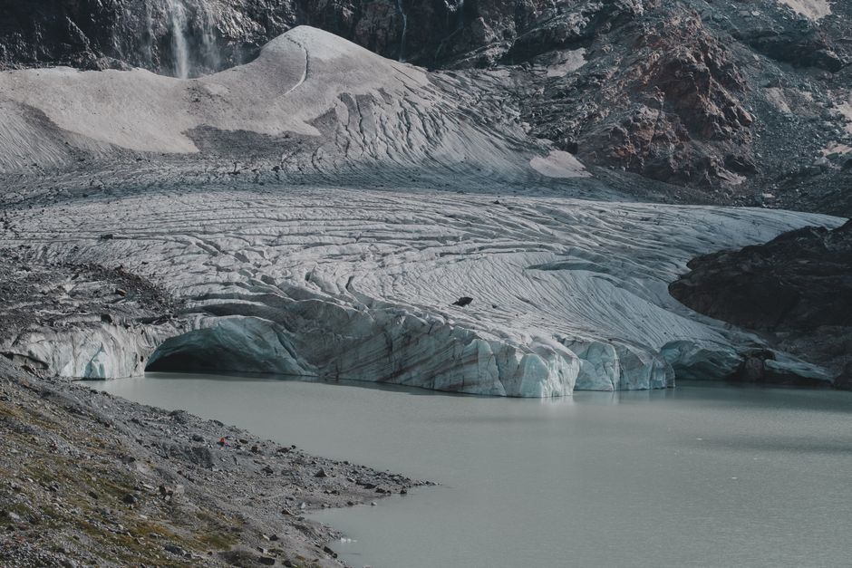
Another type of depositional barrier is the terminal moraine, which marks the farthest advance of a glacier. When the glacier retreats behind this ridge, water can accumulate between the ice front and the moraine, forming a proglacial lake. These lakes are often temporary, as the glacier continues to retreat or the moraine erodes. In the UK, examples of moraine-dammed lakes exist in the Lake District, such as Blea Water, which sits in a cirque behind a substantial moraine rampart.
Kettle Lakes and the Legacy of Buried Ice
Not all glacial lakes are formed behind moraines. Some emerge when blocks of ice become detached from the retreating glacier and are partially or completely buried by sediment. Once the ice block melts, it leaves behind a depression, or kettle, which fills with water. Kettle lakes are typically small, round, and relatively shallow. They are most common in areas of glacial outwash plains, where meltwater streams deposit sand and gravel around stagnant ice blocks.
The formation of a kettle lake depends on the timing of ice burial and sediment accumulation. If the ice block is thick and the surrounding sediment is permeable, the resulting lake may be short-lived because water can drain through the porous ground. Conversely, if the depression is lined with fine clay or silt, it can hold water for thousands of years. Kettle lakes often undergo rapid ecological changes as they fill with organic matter and vegetation, eventually becoming bogs or wetlands.
In the United Kingdom, kettle lakes are less common than moraine-dammed lakes due to the country’s topography and glacial history. However, scattered examples can be found in lowland areas that were once covered by ice sheets, such as parts of Norfolk and Cheshire. These lakes provide valuable records of post-glacial environmental conditions, as their sediments contain pollen and other microfossils that indicate past vegetation and climate.
Changes Over Time: Sedimentation, Outbursts, and Ecological Succession
Once a glacial lake is established, it does not remain unchanged. Several processes alter its size, depth, water chemistry, and biological character over decades to millennia. The most continuous change is sedimentation. Streams flowing into the lake carry sediments that gradually fill the basin. In proglacial settings, this sediment input is often high due to abundant meltwater and exposed freshly ground rock flour. Over time, deltas may form at the inlet ends, and the lake becomes shallower. Eventually, a lake can become completely filled, giving way to a flat plain or a wetland.
Another important process is the possibility of catastrophic drainage. As mentioned earlier, moraine dams can fail, releasing the entire lake in a short time. Outburst floods can reshape downstream valleys, deposit thick layers of sediment, and create new landforms. In some cases, a lake may drain and refill multiple times as the glacier advances and retreats. For example, during the last deglaciation, large proglacial lakes in North America and Europe experienced repeated fill-and-drain cycles, leaving clear evidence in the sedimentary record.
Ecologically, glacial lakes undergo succession. Initially, they may have low nutrient levels and cold, clear water, supporting only simple organisms like algae and cold-water fish. As nutrient inputs increase from surrounding soils and vegetation, the lake becomes more productive. Algal blooms, submerged plants, and a greater diversity of invertebrates may appear. Eventually, the lake may transition to a marsh or fen. This process is influenced by climate, catchment geology, and human activity. In the UK, many glacial lakes in the Lake District now show signs of eutrophication due to agricultural runoff, altering their natural ecological trajectory.
Implications for Landscape Evolution and Climate Research
Understanding how glacial lakes form and change is not only a matter of geological curiosity. These lakes serve as sensitive indicators of past and present environmental conditions. The sediments that accumulate in glacial lakes preserve records of glacial activity, volcanic eruptions, and climate shifts. By analysing sediment cores, scientists can reconstruct the timing of glacier retreats, the frequency of outburst floods, and the history of vegetation in the surrounding area.
In the context of modern climate change, glacial lakes are receiving renewed attention. In high mountain regions such as the Himalayas and the Andes, the retreat of glaciers is creating new lakes that may pose risks to downstream communities. These lakes can grow rapidly and are often dammed by unstable moraines. Monitoring their evolution and modelling potential outburst scenarios is a growing field of research. The principles learned from studying ancient glacial lakes in places like the United Kingdom help inform these contemporary assessments.
Lake Insights, as an organisation dedicated to the study of lake systems, emphasises that each glacial lake is a product of its unique history and setting. While general patterns exist, local factors such as bedrock geology, climate regime, and human intervention can produce wide variations. Continued observation and interdisciplinary research remain essential for predicting how these dynamic water bodies will evolve in a changing world.